About SITREP Tactical Mapping (iTAK)
Streamlined situational awareness platform for real-time data capture and sharing. Description SITREP is a tactical mapping tool designed to maximize situational awareness and operational readiness. Summary C
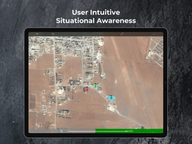
Streamlined situational awareness platform for real-time data capture and sharing.
Description
SITREP is a tactical mapping tool designed to maximize situational awareness and operational readiness.
Summary
Conceived by senior leaders from the U.S. Special Operations Forces (SOF) community, SITREP allows for rapid data collection and streamlined report generation. SITREP is the first mapping tool that empowers the concept of Every Soldier a Sensor. The intuitive interface enables discreet, real time recon to boost effectiveness in the field. SITREP augments the standard functionality of data capture and storage with all the tools needed for Military, Law Enforcement, and First Responder operations.
SITREP Defining Features
- Team Sharing - Real time data sharing between users subscribed to the same team.
- BFT Location Sharing - Real time team member location tracking.
- Secure Comms - Secure text/voice comms between team members.
Additional Features
- Integrated DOD symbol library - Annotate any point of interest with MIL-STD 2525 library.
- Rapid Symbol Builder - Select symbol type and update with appropriate IFF/Observation/Conditions in seconds.
- Easy drop pins - Mark points of interest with long press on the map, Mark button, and Voice recognition pin drop.
- SALUTE Report - Simple entry SALUTE report takes the hassle out of paperwork.
- Sketch mode - Add handwritten annotations, notes, diagrams to any point of interest or map feature.
- Photo tagging - Append photos to any location
- Audio pin - Quickly create an audio annotation pin with location and vital specs for quick recon without being slowed by data entry.
- Night vision mode - Convert to red screen for night vision optics.
- Coordinate Systems - MGRS, UTM, USNG, and Cartesian.
- Augmented Reality - View your inputted points of interest overlaid on a live A/R viewer.
Developed and field tested by SOF operators throughout the special operations community.
Help/Support:
- Youtube video tutorials: https://www.youtube.com/channel/UCfcuyDZ_JanBIceH01bdHwQ?view_as=subscriber
- SITREP Support Page: http://www.obscurityllc.com/support.html
_______________________
Available Subscription Add-ons:
Teams: share data in real-time through the cloud.
Teams + Blue Force Tracking (BFT): BFT adds team chat and live team member tracking
Terms:
- Payment will be charged to iTunes Account at confirmation of purchase
- Subscription automatically renews unless auto-renew is turned off at least 24-hours before the end of the current period
- Account will be charged for renewal within 24-hours prior to the end of the current period the full price shown above
- Subscriptions may be managed and auto-renewal may be turned off by going to your Account Settings after purchase
- No cancellation of the current subscription is allowed during active subscription period
- Privacy Policy: obscurityllc.com/privacy.html
- A separate end-user license agreement is required for each team data sharing user. See apple.com/legal/itunes/us/terms.html for details
– Any unused portion of any free trial period will be forfeited when a subscription is purchased
Jun 24, 2020
Version 3.3
- Fixed Crash for devices running iOS 11 or 12
- Enhanced A/R functionality with distance and azimuth displayed for objects observed in A/R viewer
- Support for an introductory list of Military Task symbols
- New map screenshot feature with timestamp and SITREP menu symbols removed
Previous Versions
Here you can find the changelog of SITREP Tactical Mapping (iTAK) since it was posted on our website on 2021-12-17 23:13:06.
The latest version is 3.3 and it was updated on 2024-04-22 08:38:12. See below the changes in each version.
SITREP Tactical Mapping (iTAK) version 3.3
Updated At: 2020-06-24
Changes: Jun 24, 2020 Version 3.3
- Fixed Crash for devices running iOS 11 or 12
- Enhanced A/R functionality with distance and azimuth displayed for objects observed in A/R viewer
- Support for an introductory list of Military Task symbols
- New map screenshot feature with timestamp and SITREP menu symbols removed
Disclaimer
Official App Store Link
We do not host SITREP Tactical Mapping (iTAK) on our servers. We did not scan it for viruses, adware, spyware or other type of malware. This app is hosted by Apple and passed their terms and conditions to be listed there. We recommend caution when installing it.
The App Store link for SITREP Tactical Mapping (iTAK) is provided to you by apps112.com without any warranties, representations or guarantees of any kind, so access it at your own risk.
If you have questions regarding this particular app contact the publisher directly. For questions about the functionalities of apps112.com contact us.